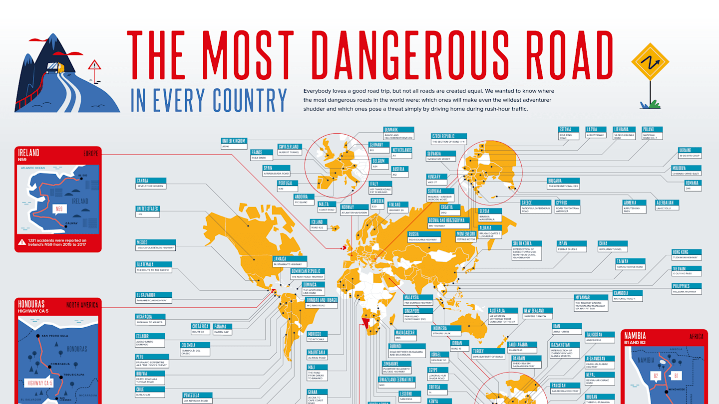
Every country has “that road.” Locals say its name with a little pause. Travelers hear about it from rental-car agents, bus drivers, or one very confident backpacker who insists, “It’s fine if you don’t look down.” On a map, these routes may appear as innocent lines: a mountain pass here, a desert highway there, a jungle road curling through green terrain like a loose shoelace. In real life, the most dangerous road in every country is rarely dangerous for just one reason. It is usually a cocktail of altitude, weather, speeding, weak road design, poor visibility, overloaded vehicles, and the universal human belief that “I can definitely make this turn.”
This guide explores the idea behind a global map of the world’s most dangerous roads: what makes a road hazardous, why famous “death roads” get attention, and how risk changes depending on whether you are driving, riding a bus, cycling, walking, or simply trying to cross the street with groceries and dignity intact. It also highlights well-known examples from different countries, using real road-safety patterns and recognizable routes rather than internet folklore dressed up in a reflective vest.
What Makes a Road the “Most Dangerous” in a Country?
A road can be dangerous because it has a terrifying reputation, because it records a high number of crashes, or because its design leaves almost no room for mistakes. These are not always the same thing. A dramatic cliff road may look scary in photos, but a flat highway with high speeds, poor lighting, and heavy truck traffic may kill far more people. That is why the phrase “most dangerous road” needs context.
Road-safety researchers often look at factors such as fatal crash rates, traffic volume, lane width, shoulder quality, median barriers, pedestrian protection, intersection design, speed limits, enforcement, and emergency response times. Mountain roads add another layer: landslides, fog, snow, hairpin turns, falling rocks, and drivers who suddenly discover that gravity is not just a theory from science class.
The Difference Between Scary and Statistically Dangerous
Some roads are famous because they look cinematic. Bolivia’s North Yungas Road, often called Death Road, became globally known for its narrow ledges, steep drops, and history of fatal crashes before a safer alternative route reduced regular traffic. Norway’s Trollstigen looks like a ribbon dropped from a giant’s pocket. Romania’s Transfăgărășan Highway bends through the Carpathian Mountains in a way that makes photographers happy and nervous passengers reconsider breakfast.
But many of the deadliest roads are less photogenic. They are ordinary highways outside fast-growing cities, rural roads with no forgiving shoulders, or long corridors where fatigue and speed turn small mistakes into life-changing events. In the United States, for example, rural roads have historically carried a disproportionate share of fatal crashes compared with the percentage of people living in rural areas. Around the world, the same pattern appears in different forms: distance, speed, delayed medical care, and road departure crashes can make remote roads especially unforgiving.
A Global Road-Risk Map: The Usual Suspects
If you plotted the most dangerous road in every country on a world map, several categories would quickly appear. Some roads are dangerous because of geography. Others are dangerous because of traffic culture, poor maintenance, rapid urbanization, or climate. The map would not simply say, “Here be dragons.” It would say, “Here be missing guardrails, sudden fog, livestock, overloaded buses, aggressive overtaking, and one pothole large enough to have its own weather system.”
Mountain Roads: Beauty With a Steering-Wheel Disclaimer
Mountain roads dominate lists of the world’s most dangerous routes because the hazards are easy to see. Sharp switchbacks, narrow lanes, steep drop-offs, and unstable slopes create a high-risk environment even before weather joins the party. Roads like the Karakoram Highway through Pakistan and China, India’s Zoji La Pass, Nepal’s Himalayan routes, and Peru’s Andes roads are legendary not only for their views but also for their thin margins of error.
These roads often serve communities that depend on them for trade, school access, medical care, and tourism. That matters. Calling a road “dangerous” should not turn it into a thrill-seeking checklist. For local drivers, it is not an extreme sport; it is Tuesday.
Desert Highways: Long, Fast, and Deceptively Quiet
Desert roads can feel safer than they are. Visibility may be excellent, traffic may be light, and the horizon may look calm enough for a postcard. Then come fatigue, high speeds, tire failure, sand drifts, extreme heat, and huge distances between help. Routes through parts of Saudi Arabia, Namibia, Australia, the American Southwest, and North Africa can become dangerous precisely because drivers relax too much.
A straight road is not automatically a safe road. In fact, long straight sections can encourage speeding and inattention. The most dangerous moment may not be the dramatic curve; it may be the tenth hour of driving when the scenery has become a beige screensaver.
Urban Arteries: Where Everyone Is in a Hurry
In many countries, the most dangerous road is not a remote mountain route but a major urban corridor. These roads combine cars, buses, motorcycles, bicycles, pedestrians, delivery riders, informal crossings, and impatient drivers into one moving puzzle. High-speed traffic passing through neighborhoods is especially risky because people must live around it: walking to school, catching buses, crossing for work, and navigating intersections that were designed more for vehicles than humans.
Cities in rapidly motorizing countries often face a difficult transition. Vehicle ownership rises faster than road design, enforcement, and public transport systems can adapt. The result is a road environment where the vulnerable userspedestrians, cyclists, and motorcyclistscarry a heavy share of the danger.
Famous Examples of Dangerous Roads by Country
A true “most dangerous road in every country” map would need official crash data, local context, and frequent updates. Still, several roads are widely recognized for their risk profile, history, or conditions. These examples show how danger changes from one country to another.
Bolivia: North Yungas Road
Bolivia’s North Yungas Road is probably the most famous dangerous road on earth. It winds between La Paz and the Yungas region, with narrow sections, cliff edges, fog, waterfalls, and a past reputation for deadly crashes. Today, much traffic uses a newer route, and the old road is better known as an adventure cycling destination. Even so, its legacy remains powerful: it is the road that made “Death Road” a global phrase.
India: Zoji La Pass
Zoji La Pass connects Kashmir and Ladakh through high-altitude Himalayan terrain. Snow, landslides, narrow passages, military traffic, and seasonal closures make it one of India’s most challenging routes. It is not just a road; it is a test of patience, planning, and whether your vehicle’s brakes have been living a responsible lifestyle.
Pakistan and China: Karakoram Highway
The Karakoram Highway is one of the world’s highest paved international roads. It is also a masterpiece of engineering in a harsh environment. Landslides, rockfall, altitude, snow, and remote conditions make parts of the route hazardous. Yet it remains a vital connection and a bucket-list journey for travelers who respect mountain driving rather than treating it like a video game with better scenery.
Romania: Transfăgărășan Highway
Built through the Carpathian Mountains, Romania’s Transfăgărășan Highway is famous for sweeping curves, steep gradients, tunnels, and dramatic viewpoints. It is beautiful enough to make drivers slow down for photos, which is good, because going too fast here is a terrible idea. Weather changes quickly, and the road is typically seasonal because winter conditions can make it unsafe.
Norway: Trollstigen
Norway’s Trollstigen, or “Troll’s Ladder,” is a mountain road with tight hairpin bends and steep slopes. It is engineered with Nordic seriousness, but nature still gets a vote. Rain, fog, tourist traffic, and narrow turns make attention essential. It is less chaotic than some dangerous roads, but the consequences of carelessness are still very real.
Peru: Mountain Roads Through the Andes
Peru’s Andean roads are often listed among the world’s riskiest because they combine altitude, curves, landslides, buses, trucks, and long distances. Some routes connect remote communities where alternative transport is limited. In places like these, road safety is not simply about warning signs; it is about investment, maintenance, emergency access, and safer vehicle standards.
United States: High-Risk Rural Highways
The United States has many roads that attract danger rankings, from parts of Interstate 4 in Florida to isolated highways in Alaska and desert routes in the Southwest. But the broader pattern is more important than any single road name: rural roads can be especially deadly due to higher speeds, road departures, limited lighting, long emergency response times, and inconsistent seat belt use. The most dangerous American road may depend on whether you measure total fatalities, fatalities per mile, crash rate, or risk per traveler.
Vietnam: Mountain Passes and Mixed-Traffic Corridors
Vietnam’s most challenging roads often include mountain passes such as the Hải Vân Pass and steep northern routes through Hà Giang and other highland provinces. These roads are spectacular, but they demand respect: sharp curves, rain, fog, motorbikes, buses, trucks, and occasional road-surface surprises can turn a scenic trip into a serious test. In lowerland areas, mixed traffic and high motorcycle use create a different kind of risk, especially at intersections and urban approaches.
Why a Country-by-Country Dangerous Road Map Is Hard to Make
It sounds simple: find the most dangerous road in each country and put it on a map. In practice, it is messy. Countries collect crash data differently. Some report fatalities within 24 hours, others within 30 days. Some publish detailed road-level data, while others release national totals only. In many regions, crashes may be underreported, especially when they happen far from major cities.
There is also the tourism problem. The road that appears most often in travel articles may not be the road with the highest crash risk. A cliff road with a scary nickname gets clicks. A suburban arterial with poor pedestrian crossings gets hospital admissions. Both matter, but they tell different stories.
How a Better Map Would Rank Road Danger
A responsible map of dangerous roads should use several layers of data. First, it should include crash history: fatalities, serious injuries, and crash frequency. Second, it should adjust for exposure, meaning traffic volume and road length. A road with 50 deaths and millions of vehicles may be less risky per trip than a remote road with fewer deaths but very little traffic. Third, the map should include infrastructure risk: lane separation, shoulder width, curve quality, roadside hazards, pedestrian protection, lighting, and speed environment.
Finally, the map should include seasonal and user-specific risk. A road may be manageable in dry weather and dangerous during monsoon season. A highway may be tolerable for car occupants but extremely risky for motorcyclists or pedestrians. Good road safety is not one number; it is a full weather report for human vulnerability.
The Biggest Risk Factors Shared by Dangerous Roads Worldwide
Speed
Speed is the great risk multiplier. It reduces reaction time, increases stopping distance, and makes crashes more severe. On a road with curves, pedestrians, animals, or poor shoulders, a small speed increase can create a much larger danger increase. Speed is also sneaky because it feels normal once traffic around you is doing the same thing.
Roadside Hazards
Trees, cliffs, ditches, poles, walls, and unprotected drop-offs make road-departure crashes more severe. Safer roads use clear zones, barriers, forgiving shoulders, and better curve design. Dangerous roads often lack these features, especially in rural or mountainous areas where construction is expensive.
Poor Visibility
Fog, dust, rain, snow, night driving, missing lane markings, and weak lighting all increase risk. A road does not need to be narrow to be dangerous if drivers cannot see what is coming. Visibility problems are especially serious when mixed with high speeds and surprise obstacles.
Mixed Traffic
Roads become more dangerous when fast vehicles share space with slow vehicles, motorcycles, bicycles, pedestrians, carts, animals, and roadside vendors. This is common in many countries where roads serve both transport and daily life. The safest systems separate users where possible and reduce vehicle speed where separation is not realistic.
Weak Emergency Response
On remote roads, the crash is only the beginning. Long distances to hospitals, limited phone coverage, and delayed rescue can make injuries more severe. This is one reason rural roads can be so deadly: help may simply be too far away.
What Travelers Should Learn From the Map
The goal of a dangerous-road map should not be fear. It should be preparation. Roads do not become safer because we gasp at drone footage. They become safer when drivers slow down, governments improve design, vehicles are maintained, and travelers understand local conditions before setting out.
If you are planning to drive abroad, do not rely only on viral lists. Check seasonal closures, local weather, road-condition updates, and transport alternatives. In some countries, hiring a local driver is not a luxury; it is a smart safety decision. In others, public buses may be convenient but vary widely in safety standards. Motorbike routes can be unforgettable, but “unforgettable” should not mean “I still hear the horn in my dreams.”
Experience Notes: What Driving the World’s Dangerous Roads Teaches You
The first lesson from dangerous roads is that confidence is not the same as competence. Many travelers begin with the same thought: “I drive at home, so I can drive here.” Then the road introduces a new syllabus. The lanes are narrower. The signs are different. A truck appears halfway into your lane around a blind bend. A goat makes a bold career move. Suddenly, your home driving experience feels like training wheels with cup holders.
The second lesson is that local knowledge is gold. Local drivers know where fog gathers in the afternoon, which curve hides loose gravel, where buses swing wide, and which “shortcut” is actually a scenic invitation to regret. Maps are helpful, but they rarely show the rhythm of a road. They do not tell you that a mountain pass becomes slippery after the first rain or that a quiet-looking section is where drivers speed because it follows 20 minutes of slow curves.
The third lesson is patience. Dangerous roads punish hurry. Leaving early, accepting delays, and refusing risky overtakes are simple choices that make a large difference. On mountain routes, the safest driver is often not the fastest or the bravest. It is the person who understands that arriving late is still arriving. The road does not hand out medals for aggressive cornering, and if it did, the medal would probably be shaped like an insurance form.
The fourth lesson is that vehicle condition matters more than travelers expect. Tires, brakes, lights, mirrors, windshield wipers, and seat belts are not boring details; they are the quiet heroes of road safety. On a high-risk route, a worn tire or weak brake is not a small inconvenience. It is a bad idea with wheels. Before long drives, especially in mountains or remote areas, checking the vehicle is as important as checking the route.
The fifth lesson is humility. Some roads are not worth driving yourself. A traveler may be experienced, careful, and calm, yet still unfamiliar with local traffic behavior, road surfaces, weather patterns, and emergency options. Choosing a train, a licensed bus company, a local driver, or a different route is not cowardice. It is smart travel. The best road story is the one you get to tell comfortably afterward, preferably while eating something warm and not Googling “how much does a tow truck cost in the mountains.”
The final lesson is that dangerous roads reveal how road safety is a shared responsibility. Drivers matter, but so do engineers, policymakers, police, vehicle inspectors, transport companies, and communities. A safer road is not created by one warning sign that says “Be Careful” in fading paint. It is created by better design, lower speeds, reliable enforcement, protected crossings, safer vehicles, and public expectations that human life is more important than shaving six minutes off a trip.
Conclusion
A map of the most dangerous road in every country is more than travel trivia. It is a window into how geography, infrastructure, speed, enforcement, and human behavior combine on the world’s roads. Some dangerous roads are famous because they cling to cliffs or twist through mountains. Others are dangerous because they are ordinary, busy, and badly designed for the people who use them every day.
The smartest way to read such a map is not as a dare, but as a reminder. Roads are systems. When they are designed well, maintained properly, and used responsibly, they save lives quietly. When they are neglected, overloaded, or treated like racetracks, they become dangerous in ways that no beautiful view can excuse. Whether you are crossing a city avenue, riding through a mountain pass, or planning a once-in-a-lifetime road trip, the best travel souvenir is still the simplest one: getting home safely.
Note: This article is written for web publication and is based on real road-safety patterns, internationally recognized road-risk factors, and widely reported examples of dangerous roads around the world.